Itinerary
Day 1 Manali to Khanjer Drive, 140 km, 5-6 hours drive.
Pick up point: Manali Volvo Station
Arrival Pickup from Manali and drive Khanjer, you can enjoy the views of scenic Lahaul Valley, passing through Udaipur and Keylong districts. Breakfast enroute on direct payment basis. On arrival Khanjer, check into the local homestay. Eexperience warm hospitality and traditions. Overnight stay at Khanjer.
Day 2: Trek to Tharang / Yolling from Khanjar, Trek – 7.2 km , Altitude 10000 ft to 12122 ft
Easy-Moderate. Gradual climb through a series of switchbacks till Tharang.
The farmlands grow a variety of crops. Pretty villages and a cricket ground.
The road ends at Khanjar. You cross a suspension bridge that hangs over Miyar Nala to enter Kanjar village. This is the last village on the route. It is 31 km from Udaipur. There are 13 villages inside this valley.
From here the trail starts in a series of switchbacks while farms accompany you to the first campsite, Tharang. The place has a beautiful water stream nearby. Also, the flat meadow is used by locals to play cricket on occasions.
You also find many steep rockfaces around this region which have attracted the attention of rock-climbers.
The best part of the Tharang campsite is that you get to view Lahaul’s second-highest and most beautiful peak, Menthosa. It is known as the crown of Miyar Valley.
Day 3: Trek from Tharang to Zardong, Trek – 11.4 km , Altitude 12122 ft to 12667 ft
The rocky mountain massif of Tharang. The pretty campsite of Zardong.
In the course of the whole trek, this is a slightly more challenging day. The trek initially is a flat walk and then there is a 10-15 minute descent to the bridge. From the bridge, there is a 20-minute steep climb towards Gompa and to the right is Gompa Nala. A little ahead you will find a shepherd’s hut and around is a small water body which is also known as Gompa lake.
From the shepherd’s hut, for 30 minutes the route gradually descends towards a flat meadow patch. From here a stretch of boulder section comes which again takes you up and down, the section gets slightly tricky because you will be walking over the edges at certain points. Also, the ups and downs across boulder sections can get slightly tiring. But the steep pyramidical mountains surround you all around.
Eventually, the route descends to a flat region alongside the river. Here, the best part is to feel the beach-type walks and the constant gushing water.
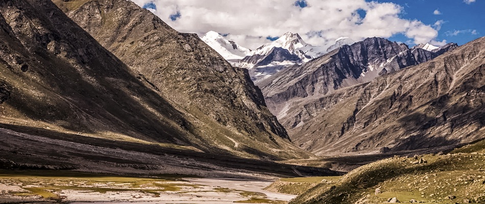
As you move more inwards the valley, the valley after every Nala gets wider and grander. Everywhere you look around there are valley openings. The trail is covered with multiple types of flowers.
Day 4: Trek from Zardong to Palpu, Trek – 8 km, Altitude 12667 ft to 12782 ft
The route walks alongside the river. The major portion involves flat walks. You’ll come across the region by the name Chhudong.
Chhudong is a huge meadow patch which is located right next to the river. The river here is very soothing and wider than anywhere else along the trek. The murky water on your right goes all the way to the snout. Since the valley has an active river running in between, by just walking alongside the river the trail is well marked and easily noticeable. It’s hard for anyone to get confused about the route.
After the flat meadows of Chhudong, the valley squeezes with boulder patches. Then comes the cold stream from a valley that is to your right. Here the stream comes from the same valley which also has Tower and Castle Peaks. Again, the trail gets flattered and you walk next to the river. After a while, again the boulder patches with few water streams need to be negotiated.
Palpu is located near Castle Peak which again is a very beautiful campsite which offers a good view of the valley and Tharang peaks. From here if the weather is clear the chances of viewing Menthosa are also high.
In the course of the whole trek, this is a slightly more challenging day. The trek initially is a flat walk and then there is a 10-15 minute descent to the bridge. From the bridge, there is a 20-minute steep climb towards Gompa and to the right is Gompa Nala. A little ahead you will find a shepherd’s hut and around is a small water body which is also known as Gompa lake.
From the shepherd’s hut, for 30 minutes the route gradually descends towards a flat meadow patch. From here a stretch of boulder section comes which again takes you up and down, the section gets slightly tricky because you will be walking over the edges at certain points. Also, the ups and downs across boulder sections can get slightly tiring. But the steep pyramidical mountains surround you all around.
Eventually, the route descends to a flat region alongside the river. Here, the best part is to feel the beach-type walks and the constant gushing water.
As you move more inwards the valley, the valley after every Nala gets wider and grander. Everywhere you look around there are valley openings. The trail is covered with multiple types of flowers.
Day 5: Trek from Palpu to Miyar Glacier back to Palpu, Trek – 8 km, Altitude 12782 ft to 13202 ft to 12782 ft
On this day we will go to the snout of the glacier which comes after going through a boulder section and a stream. Eventually, you reach a place which is the last small meadow patch located near seven icy ponds, this place is known as Kesar Yon Chu. From here on the actual glacier starts. The snout of the glacier is just 30 minutes from the ponds.
Once you have reached the snout, Spend a good amount of time. Then return from here on the same route. There are two more river crossings on the way back.
From Chhudong, the region is flat and you are walking alongside the river. After this, you come across the tricky portion till Gompa. You ascend and descend multiple times. Finally, once you reach Gompa Nala.
You are done with the trek for the day. From the vantage point, you can see both sides of the valley.
The route walks alongside the river. The major portion involves flat walks. You’ll come across the region by the name Chhudong.
Chhudong is a huge meadow patch which is located right next to the river. The river here is very soothing and wider than anywhere else along the trek. The murky water on your right goes all the way to the snout. Since the valley has an active river running in between, by just walking alongside the river the trail is well marked and easily noticeable. It’s hard for anyone to get confused about the route.
After the flat meadows of Chhudong, the valley squeezes with boulder patches. Then comes the cold stream from a valley that is to your right. Here the stream comes from the same valley which also has Tower and Castle Peaks. Again the trail gets flattered and you walk next to the river. After a while, again the boulder patches with few water streams need to be negotiated.
Palpu is located near Castle Peak which again is a very beautiful campsite which offers a good view of the valley and Tharang peaks. From here if the weather is clear the chances of viewing Menthosa are also high.
Day 6: Trek from Palpu to Gompa, Trek – 14 km, Altitude 12782 ft to 12665 ft
Close-up of Menthosa, glacier view, excellent sunrise/sunset spot
Get up early morning have your breakfast and gradually descend toward Gompa, campsite.
Day 7: Trek from Gompa to Khanjer. Drive to Manali, Trek – 11.2 km, Altitude 12665 ft to 11564 ft, Drive 140 km, 5hours
Easy, almost flat walk till Thareng. The flat walks in the valley.
Walking toward the Thanpattan region is beautiful and looks like Clint Eastwood’s movie scenes. For kilometres, it’s flat walks. It’s quite dramatic to walk back.
Dropping point: Manali Hotel or Volvo Station